

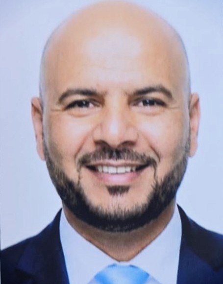
Abdelmonaam Ghodhban
Doha
Profil professionnel
Well equipped land surveyor with a wide range of experience in engineering duties such as planning, design, construction and maintenance, my goal is to utilize this knowledge to contribute to the success of the company. My expertise in CAD technologies and familiarity using topographical equipment are very helpful in performing my duty.
Vue d'ensemble
4
4
Languages
2
2
years of post-secondary education
14
14
years of professional experience
Expérience
Land Surveyor
MINISTRY OF MUNICIPALITY OF QATAR
Doha
2020.04 - 2025.03
* Cadastral & Property Surveys: Boundary Delimitation defining land parcels, property limits, legal easements, rights-of-way, and coordinate cadasters under national frameworks like the Qatar National Geodetic Datum (QND95)
* Topographic & Site Mapping: Conducting detailed field measurements of land contours, elevations, and physical features using Total Stations, GPS/GNSS, and 3D laser scanners to feed municipal GIS and map-making databases.
* Construction & Setting-Out Verification: Marking structural grids, foundation lines, road alignments, and service levels for municipal building and infrastructure projects, followed by as-built verifications.
* Encroachment & Compliance Reporting: Investigating land use violations, verifying site boundaries against title deeds, and reporting unauthorized building or boundary overlaps to municipal authorities.
* Technical Documentation & Drafting: Preparing official sketches, boundary maps, legal descriptions, and digital CAD/GIS drawings required for property registration, land valuation, and permit approvals.
Land Surveyor
INTERNATIONAL TRADE AND DEVELOPPMENT CO ITD
2016.06 - 2020.12
- Checked alignment and level of water pipeline to ensure compliance with project specifications.
- Coordinated with client and consultant surveyors to verify and approve site activities, ensuring adherence to project standards.
- Doing all required survey work such as: marking footing location, columns location, levelling, axes....
- Setting out and marking for alignment of trench to be excavated.
- Checking the leveling of excavation.
- Making the survey report of whatever work to be inspected.
- Managed workers during survey downtimes to maintain project workflow and minimize delays.
- Marked and surveyed sleeper and pipe supports according to drawings.
- PROJECT: BUILD A PALACE AT PEARL CITY
Land Surveyor
DOREX ENGINEERING
QATAR
2016.06 - 2018.01
- Determined boundaries using surveying equipment and mathematical calculations.
- Calculated height, depth, property lines, and other characteristics of terrain.
- Read and interpreted legal documents, construction drawings and maps to complete surveys.
- Documented survey findings and prepared detailed reports and plats.
- Conducted surveys to design, research and analyze mapping systems.
- Utilized Revit and AutoCAD to prepare drawings and maps of properties.
- Worked effectively in team environments to make the workplace more productive.
LAND SURVEYOR
SOQ-JV
2015.01 - 2016.05
- Set out and marked slab and wall locations to ensure precise construction alignment.
- Marked and surveyed construction joint and CJ line to facilitate accurate project execution.
- Checked level and alignment of walls according to drawings to maintain structural integrity.
- Defined the route for the tunnel boring machine to ensure accurate tunneling.
- (DOHA METRO MAJOR STATION PROJECT MUSHIREB METRO STATION & EDUCATION CITY STATION)
LAND SURVEYOR
AL NOOR ENGINEERING CO QATAR
2013.11 - 2014.12
- Set out and controlled levels for infrastructure work, including excavation, formation, aggregate, center line for pipe laying, structure work, and invert levels per approved drawings.
- Executed field operations for road construction, ensuring adherence to project specifications and timelines.
- Set out and established levels for road works, including excavation and filling for road formation, subbase, road base, base course, wearing course, and curb stones.
- Ensured control points were accurate to maintain project integrity.
LAND SURVEYOR
ATTAKADOM CO LIBYA
2012.08 - 2013.09
- Setting out and levels (Infrastructure work) for excavation, formation, aggregate, center line for laying pipe, structure work and controlling invert levels as per approved drawings.
- Set out and checked road works, curb stones, road base, drainage layers, base and wearing course, road marking, and walkways.
- Set out levels for road works, including excavation and filling for road formation, subbase, base course, wearing course, and curb stones.
- Setting out and checking sewerage water Drainage network.
- Conducted topographic surveys to create project contours and accurately calculate quantities post-grading.
- Checking and fixing of control points & Taking Cross-Section.
- Coordinated with client and consultant surveyors to check and approve site activities, ensuring compliance with project specifications.
- Supported field operations for MEP systems and roadworks.
Land Surveyor
MABHD – SFAX TUNISIA
2011.07 - 2012.07
- Developed as-built drawings of land to support building permit applications.
- Parcelled land into smaller divisions to facilitate development.
- Cleared legal cases by presiding over court sessions.
- Oversaw geometrical studies at dedicated center to ensure accurate data collection.
Formation
BTS (advanced technician's certificate) - CONSTRUCTION
Gabès Sectoral Training Center for Construction
GABES TUNISIA 2009.09 - 2011.07
Compétences
- Topographic surveys
- Surveying Software
- GIS Software
- AutoCAD (Road &Building)
- AutoCAD civil design
- AutoCAD Land Development
- Topcon GTS 225
- Sokkia Set1x,Set2x,Set3x
- Trimble S3,S6,M3
- Leica Builder 503
- Nikon 552 DTS
- Theodolite
- MS Office
- Excel
OFFICIAL PROFILE:-
- All Shop Drawings and As Built Drawings for the above works which consist of civil, structural, layout as well as design drawings for additional works are being prepared
- Worked using Auto CAD and land development programs.
- Created Excel spreadsheets to link them to AutoCAD files.
- Designed Road profiles and plans and make drawings of culvert
Language
Arabic
NATIVE LANGUAGE
Arabic ( mother )
Proficient
C2
English
Advanced
C1
French
Intermediate
B1
DECLARATION
I hereby declare that the above written particulars are true to the best of my knowledge and belief. ABDELMONAAM GHODHBAN
Chronologie
Land Surveyor
MINISTRY OF MUNICIPALITY OF QATAR
2020.04 - 2025.03
Land Surveyor
DOREX ENGINEERING
2016.06 - 2018.01
Land Surveyor
INTERNATIONAL TRADE AND DEVELOPPMENT CO ITD
2016.06 - 2020.12
LAND SURVEYOR
SOQ-JV
2015.01 - 2016.05
LAND SURVEYOR
AL NOOR ENGINEERING CO QATAR
2013.11 - 2014.12
LAND SURVEYOR
ATTAKADOM CO LIBYA
2012.08 - 2013.09
Land Surveyor
MABHD – SFAX TUNISIA
2011.07 - 2012.07
BTS (advanced technician's certificate) - CONSTRUCTION
Gabès Sectoral Training Center for Construction
2009.09 - 2011.07